Introduction: What Makes Azimuthal Equidistant Maps Special?
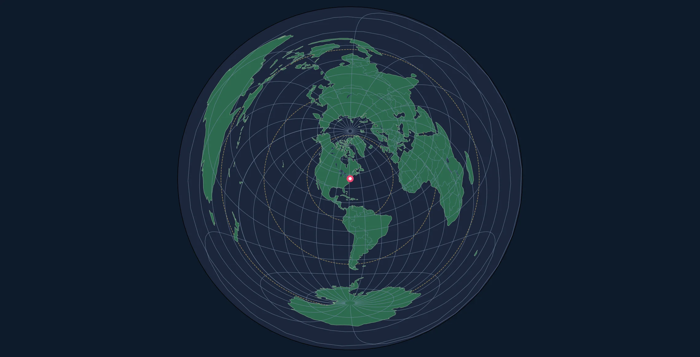
An azimuthal equidistant map is one of the most useful yet commonly misunderstood map projections. Unlike familiar rectangular projections like the Mercator, azimuthal equidistant maps are typically circular and show the entire world from a single perspective point—the map center.
The key feature that makes these maps invaluable: every point on the map is shown at its true distance and direction (azimuth) from the center point. This property makes them essential tools for:
- Ham radio operators calculating antenna beam headings
- Pilots and navigators planning great circle routes
- Seismologists measuring earthquake distances
- Military planners visualizing missile ranges
- Anyone who needs to know "how far and which direction" from a specific location
In this comprehensive guide, you'll learn how to read these maps accurately, understand what they show (and don't show), and use them effectively for navigation and distance measurement.
Understanding the Center Point
The Most Important Element
The center point is the most crucial element of any azimuthal equidistant map. Everything on the map is positioned relative to this location. Common center points include:
- North Pole – for polar navigation and Arctic studies
- Your home location – for personalized distance/direction calculations
- Major cities – for regional planning and communications
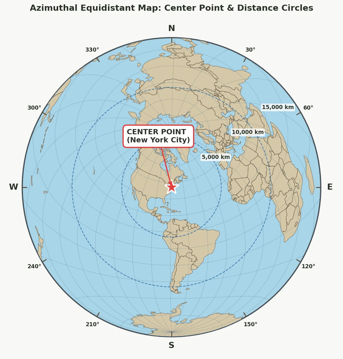
What the Center Point Tells You
From the center point, you can determine:
- True distance to any location on the map
- True azimuth (direction) to any location
- Great circle path to any destination (a straight line from center)
Key Insight: Measurements are only accurate when made from the center point. Distances between two non-center points will be distorted.
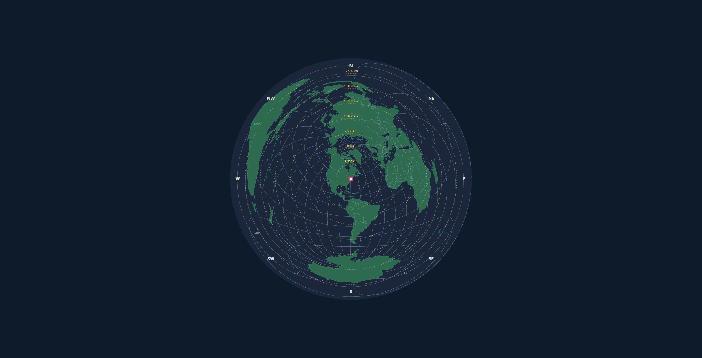
Reading Distance on the Map
Distance Circles (Concentric Rings)
Most azimuthal equidistant maps include concentric circles emanating from the center. These circles represent equal distances from the center point.
| Circle Number | Approximate Distance |
|---|---|
| 1 | 5,000 km (3,100 mi) |
| 2 | 10,000 km (6,200 mi) |
| 3 | 15,000 km (9,300 mi) |
| 4 | 20,000 km (12,400 mi) |
The outermost circle represents the antipodal point—the location exactly opposite the center on the globe, approximately 20,000 km away.
How to Measure Distance
To find the distance from the center to any point:
- Locate your target on the map
- Count the distance circles between the center and your target
- Interpolate if the point falls between circles
- Multiply by the scale indicated in the legend
Example Calculation
If your map has circles every 2,500 km and Tokyo falls between the 3rd and 4th circles from your center point (New York):
$$\text{Distance} \approx 3.5 \times 2500 \text{ km} = 8750 \text{ km}$$
Pro Tip: Use a ruler or string to measure the exact distance from center, then compare to the map's scale bar for precise measurements.
The Mathematical Relationship
On an azimuthal equidistant map, the distance from center ($\rho$) relates directly to the actual spherical distance:
$$\rho = R \cdot c$$
Where:
- $\rho$ = distance on the map from center
- $R$ = scale factor (radius of the map)
- $c$ = angular distance from center (in radians)
This linear relationship is what makes distance measurements from the center perfectly accurate.
Reading Direction (Azimuth)
Understanding Azimuth
Azimuth is the compass direction from one point to another, measured in degrees clockwise from true north:
- 0° = North
- 90° = East
- 180° = South
- 270° = West
How to Find Direction on the Map
On an azimuthal equidistant map:
- Draw a straight line from the center to your destination
- Measure the angle between this line and the north direction (usually straight up)
- The resulting angle is the true azimuth
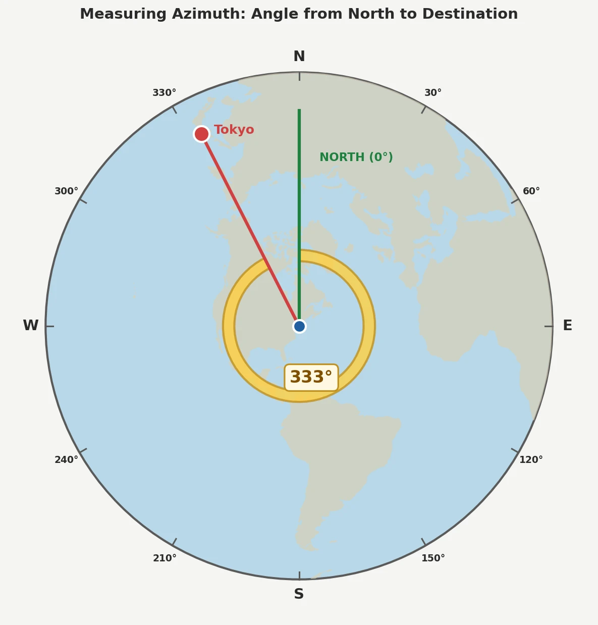
Why This Works
The projection preserves true azimuthal angles from the center. A straight line from the center represents the actual compass bearing you would travel to reach that destination via the shortest path (great circle route).
This is why ham radio operators love these maps—the direction you point your antenna matches the straight-line direction on the map.
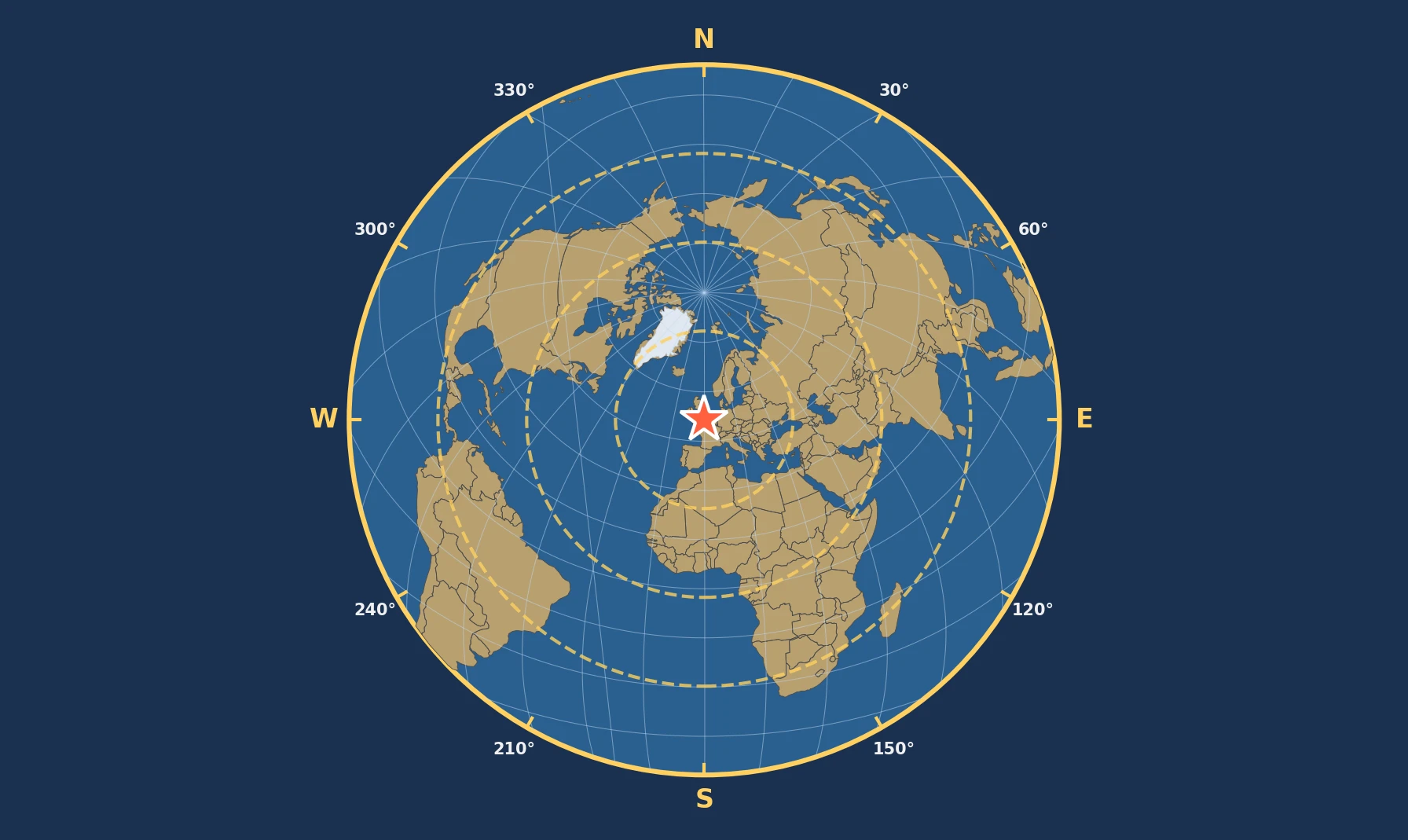
The Graticule: Latitude and Longitude Lines
How They Appear
On azimuthal equidistant maps, the graticule (grid of latitude and longitude lines) appears differently depending on the center point:
| Center Point | Latitude Lines | Longitude Lines |
|---|---|---|
| North Pole | Concentric circles | Straight lines radiating from center |
| Equator | Curved arcs | Curved lines (except central meridian) |
| Mid-latitude | Complex curves | Complex curves |
Using the Graticule for Orientation
The graticule helps you:
- Verify your location readings
- Understand distortion patterns
- Identify the equator and prime meridian
- Navigate to known coordinates
Note: The graticule lines become more distorted as you move toward the map's edge. This visual distortion doesn't affect distance/direction accuracy from center.
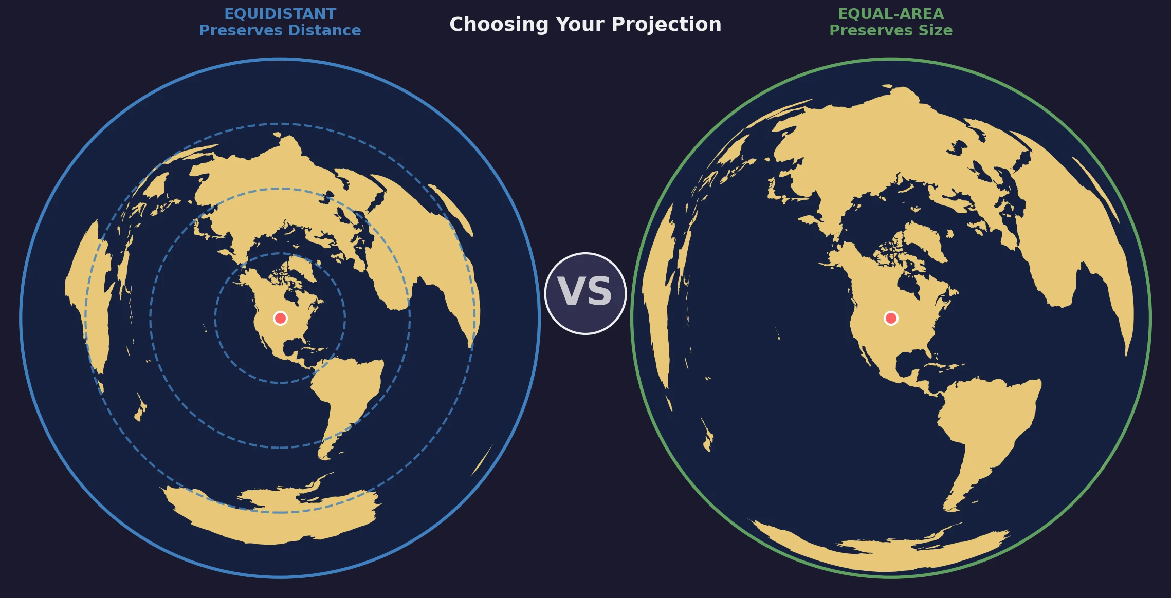
Understanding Distortion
The Distortion Trade-off
While azimuthal equidistant maps preserve distance and direction from the center, they distort other properties:
- Areas become increasingly exaggerated toward the edges
- Shapes become stretched, especially near the antipode
- Distances between non-center points are not accurate
Distortion Zones
| Zone | Distance from Center | Distortion Level | Reliability |
|---|---|---|---|
| Inner | 0 – 5,000 km | Minimal | Excellent |
| Middle | 5,000 – 10,000 km | Moderate | Good |
| Outer | 10,000 – 15,000 km | Significant | Fair |
| Edge | 15,000 – 20,000 km | Severe | Use with caution |
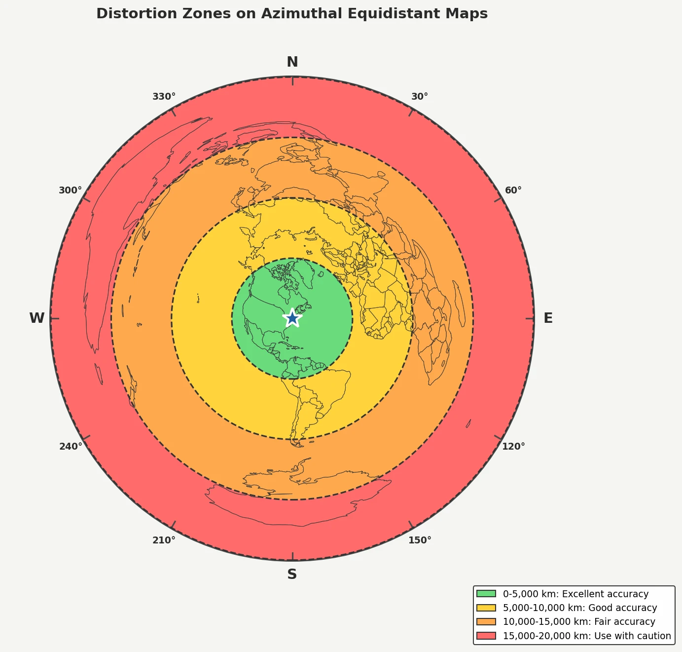
The Antipodal Effect
The antipode (the point exactly opposite the center on Earth) presents a unique challenge. On an azimuthal equidistant map, this single point becomes stretched into the entire outer edge of the circular map.
For example, if your map is centered on New York City, the antipode (in the Indian Ocean) appears as the entire outer ring—creating extreme distortion in that region.
Practical Applications
For Ham Radio Operators
Azimuthal equidistant maps are essential for amateur radio because radio signals often travel along great circle paths:
- Find your target station's location on the map
- Draw a straight line from your QTH (location) at the center
- Read the azimuth to determine your antenna bearing
- Note the distance to estimate signal propagation
Many ham operators keep a personalized azimuthal map centered on their station for quick beam heading references.
For Pilots and Navigators
Great circle routes (the shortest path between two points on Earth) appear as straight lines from the center:
- Plan your route by drawing a straight line to destination
- Measure the total distance using the scale
- Identify waypoints along the path
- Calculate initial heading from the azimuth angle
Important: The heading will change during flight. The initial azimuth is correct, but you'll need to adjust course as you travel along the great circle.
For Emergency Planning
When assessing impact zones or planning emergency responses:
- Radius circles show areas within specific distances
- Directional sectors can identify approach corridors
- Distance bands help prioritize response zones
Common Mistakes to Avoid
Mistake 1: Measuring Between Non-Center Points
Wrong: Drawing a line between Tokyo and London when your map is centered on New York, then measuring that line for distance.
Right: Use separate maps centered on each endpoint, or recalculate using the appropriate formulas.
Mistake 2: Assuming Shapes Are Accurate
Wrong: Thinking that because Australia looks stretched, it's actually that shape.
Right: Recognize that shape distortion increases with distance from center. Australia's true shape is preserved on maps using different projections.
Mistake 3: Ignoring the Center Point
Wrong: Using any azimuthal equidistant map interchangeably.
Right: Always verify the center point matches your needs. A polar-centered map won't give accurate distances from your home location.
Mistake 4: Confusing with Other Projections
Wrong: Assuming an azimuthal equal-area map (Lambert) works the same way.
Right: Equal-area projections preserve area, not distance. Always check which type of azimuthal projection you're using.
Quick Reference Card
| Task | How To |
|---|---|
| Find distance to X | Measure straight line from center to X, use scale |
| Find direction to X | Measure angle from north to center-X line |
| Plan great circle route | Draw straight line from center to destination |
| Identify antipode | Look at outer edge (stretched point) |
| Assess accuracy | Check distance from center (closer = more accurate) |
Summary
Azimuthal equidistant maps are powerful tools when you understand their unique properties:
What these maps do well:
- Accurate distance from the center point to any location
- Accurate direction from the center point to any location
- Great circle routes appear as straight lines from center
- Intuitive circular design with the world wrapped around your viewpoint
Limitations to keep in mind:
- Not accurate for distances between non-center points
- Shape and area distortion increases toward the edges
- Requires knowing the center point to interpret correctly
With practice, reading these maps becomes second nature. Whether you're a ham radio enthusiast, a pilot, or simply curious about geography, understanding azimuthal equidistant projections opens up a new way of seeing our world—from your perspective.
Next Steps
Ready to create your own azimuthal equidistant map? Use our interactive map generator to create a custom projection centered on any location you choose.
Want to learn about the alternative? Read our guide on Choosing Between Equal-Distance and Equal-Area Projections to understand when each projection type is most appropriate.