Globe to Azimuthal Equidistant Projection Animation

See how the azimuthal equidistant projection maps the three-dimensional Earth onto a flat surface, preserving true distances and directions from the center point.

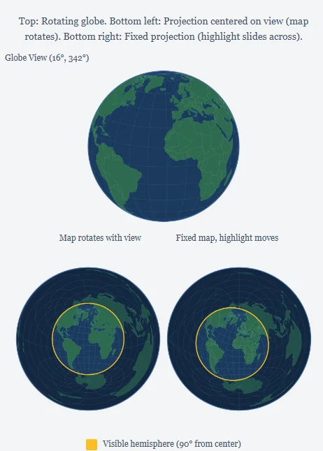
Top: Rotating globe. Bottom left: Projection centered on view (map rotates). Bottom right: Fixed projection (highlight slides across).

Loading world data...

How This Animation Works

Top: A rotating orthographic globe showing Earth from space. The visible hemisphere—the half of Earth facing you—is highlighted.

Bottom Left: An azimuthal equidistant projection that rotates with the globe. The center of this map always matches the center of the globe view, and the yellow ring shows the boundary of the visible hemisphere. Everything inside this ring corresponds exactly to what you can see on the globe above.

Bottom Right: A fixed azimuthal equidistant projection centered on 30°N, 0°E (roughly North Africa). As the globe rotates, the yellow highlight slides across this fixed map, showing which portion of the projection corresponds to the currently visible hemisphere. Notice how the circle distorts into an ellipse when the view center moves away from the projection center.

This visualization demonstrates a key property of the azimuthal equidistant projection: distances measured along any straight line from the center point are accurate. The yellow ring represents a 90° angular distance from the center—exactly one quarter of Earth's circumference.

What to Watch For

The animation compares two different mental models for the same projection. In the moving map on the left, the center point changes with the globe. The visible hemisphere stays circular because it is always centered on the projection. In the fixed map on the right, the projection center stays at 30°N, 0°E while the globe view moves. The visible hemisphere then stretches and bends as it moves away from that fixed center.

This difference explains why azimuthal equidistant maps are easiest to read when the center point is part of the question. If the map is centered on your location, distance rings and straight radial bearings have direct meaning. If the feature of interest is far from the center, the map still follows the projection formula, but shapes and areas become progressively less intuitive.

Why the Edge Distorts

A sphere cannot be flattened without distortion. The azimuthal equidistant projection chooses to protect distances and directions from the center, so the strongest distortion appears toward the outside of the disk. At the antipode, the point exactly opposite the center, the projection reaches its maximum distance. On a complete world map that opposite point spreads around the outer edge.

The yellow 90° boundary in this animation is not the outer edge of the full projection. It marks the limit of the hemisphere visible from a particular globe view. A full azimuthal equidistant map can extend to 180° from the center, about half of Earth's circumference. Beyond 90°, the map is showing places on the far side of the globe from the selected center, so shapes are much more stretched.

Related Map Tools

Use the azimuthal map generator to create a static map centered on any city or coordinate pair. For a deeper explanation of the projection tradeoffs, read the azimuthal projection guide. If you want to build a similar visualization yourself, the blog includes D3.js and Python tutorials that show how to configure projection centers, graticules, distance rings, and exported map images.